
Thank you for supporting this site ❤️
Make a donation
Make a donation
Gear up for your next adventure:
As an Amazon Associate, this site earns from qualifying purchases at no extra cost to you.
Maranhão topographic map
Click on the map to display elevation.
Thank you for supporting this site ❤️
Make a donation
Make a donation
Gear up for your next adventure:
As an Amazon Associate, this site earns from qualifying purchases at no extra cost to you.
About this map
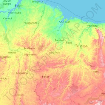
Name: Maranhão topographic map, elevation, terrain.
Location: Maranhão, Northeast Region, Brazil (-10.26194 -48.75584 -0.75824 -41.68490)
Average elevation: 689 ft
Minimum elevation: -10 ft
Maximum elevation: 3,940 ft
Thank you for supporting this site ❤️
Make a donation
Make a donation
Gear up for your next adventure:
As an Amazon Associate, this site earns from qualifying purchases at no extra cost to you.
Other topographic maps
Click on a map to view its topography, its elevation and its terrain.
Atlantic Forest
Brazil > São Paulo > Região Metropolitana de São Paulo > Ribeirão Pires
Average elevation: 2,582 ft