Geolocate

Curtis topographic map

Click on the map to display elevation.

About this map

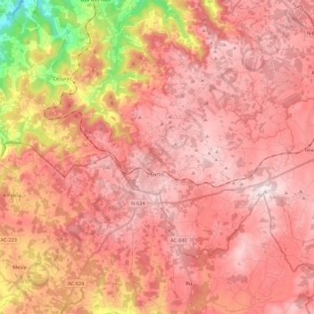
Name: Curtis topographic map, elevation, terrain.

Location: Curtis, Betanzos, A Coruña, Galicia, Spain (43.08422 -8.15978 43.18653 -7.94289)

Average elevation: 1,650 ft

Minimum elevation: 558 ft

Maximum elevation: 2,448 ft

Other topographic maps

Click on a map to view its topography, its elevation and its terrain.

Quistilan

Spain > Galicia > Betanzos

Average elevation: 554 ft

Burricios

Spain > Galicia > Betanzos > Oza-Cesuras

Average elevation: 876 ft

Tiúlfe

Spain > Galicia > Betanzos

Average elevation: 928 ft

Ansimonde

Spain > Galicia > Betanzos > Miño

Average elevation: 492 ft

As Brañas

Spain > Galicia > Betanzos > O Pazo de Irixoa

Average elevation: 1,243 ft

Cendá

Spain > Galicia > Betanzos

Average elevation: 817 ft

Cesuras

Spain > Galicia > Betanzos

Average elevation: 1,043 ft

Miño

Spain > Galicia > Betanzos

Average elevation: 135 ft

Gear up for your next adventure:

🪶Camp Gear Gift Set - Perfect gift bundle for outdoor fans
🧥Waterproof Jacket for Hiking - Breathable and rugged rain jacket for outdoor excursions
🖼️Topo Map Wall Art - Decorative topographic prints of famous peaks and regions
🛶Inflatable Kayak - Portable kayak for rivers, lakes, and expeditions
📚Navigation Handbooks - Master the art of reading topographic maps and using a compass

As an Amazon Associate, this site earns from qualifying purchases at no extra cost to you.