
Ferryville topographic map
Click on the map to display elevation.
About this map
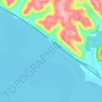
Name: Ferryville topographic map, elevation, terrain.
Location: Ferryville, Crawford County, Wisconsin, United States (43.32758 -91.11581 43.36463 -91.07213)
Average elevation: 722 ft
Minimum elevation: 610 ft
Maximum elevation: 1,129 ft
Crawford County trails, hiking, mountain biking, running and outdoor activities
Other topographic maps
Click on a map to view its topography, its elevation and its terrain.
Kickapoo River State Wildlife Area
United States > Wisconsin > Crawford County > Bell Center
Average elevation: 820 ft