
Make a donation
Gear up for your next adventure:
As an Amazon Associate, this site earns from qualifying purchases at no extra cost to you.
Sillian topographic map
Click on the map to display elevation.
Make a donation
Gear up for your next adventure:
As an Amazon Associate, this site earns from qualifying purchases at no extra cost to you.
About this map
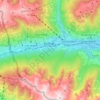
Name: Sillian topographic map, elevation, terrain.
Location: Sillian, Bezirk Lienz, Tirol, 9920, Oostenrijk (46.69909 12.35741 46.78423 12.44229)
Average elevation: 5,584 ft
Minimum elevation: 3,478 ft
Maximum elevation: 8,363 ft
Make a donation
Gear up for your next adventure:
As an Amazon Associate, this site earns from qualifying purchases at no extra cost to you.
Other topographic maps
Click on a map to view its topography, its elevation and its terrain.
Make a donation
Gear up for your next adventure:
As an Amazon Associate, this site earns from qualifying purchases at no extra cost to you.
Hinterbichl
Oostenrijk > Tirol > Bezirk Lienz > Prägraten am Großvenediger
Average elevation: 5,922 ft
Make a donation
Gear up for your next adventure:
As an Amazon Associate, this site earns from qualifying purchases at no extra cost to you.
Make a donation
Gear up for your next adventure:
As an Amazon Associate, this site earns from qualifying purchases at no extra cost to you.