
Make a donation
Gear up for your next adventure:
As an Amazon Associate, this site earns from qualifying purchases at no extra cost to you.
Nariño topographic map
Click on the map to display elevation.
Make a donation
Gear up for your next adventure:
As an Amazon Associate, this site earns from qualifying purchases at no extra cost to you.
Nariño
Nariño has a diverse geography and varied climate according to altitude: hot in the plains of the Pacific and cold in the mountains, where most of the population resides, a situation that is repeated in a north-south direction. Other important cities include Tumaco and Ipiales.
Make a donation
Gear up for your next adventure:
As an Amazon Associate, this site earns from qualifying purchases at no extra cost to you.
About this map
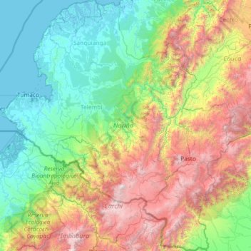
Name: Nariño topographic map, elevation, terrain.
Location: Nariño, RAP Pacífico, Colombia (0.36094 -79.00785 2.68369 -76.83371)
Average elevation: 3,793 ft
Minimum elevation: -10 ft
Maximum elevation: 15,315 ft
Make a donation
Gear up for your next adventure:
As an Amazon Associate, this site earns from qualifying purchases at no extra cost to you.
Other topographic maps
Click on a map to view its topography, its elevation and its terrain.