
Make a donation
Gear up for your next adventure:
As an Amazon Associate, this site earns from qualifying purchases at no extra cost to you.
Tarakan topographic map
Click on the map to display elevation.
Make a donation
Gear up for your next adventure:
As an Amazon Associate, this site earns from qualifying purchases at no extra cost to you.
About this map
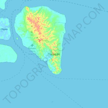
Name: Tarakan topographic map, elevation, terrain.
Location: Tarakan, North Kalimantan, Kalimantan, Indonesia (3.14002 117.47302 3.46002 117.79302)
Average elevation: 16 ft
Minimum elevation: -7 ft
Maximum elevation: 312 ft
Make a donation
Gear up for your next adventure:
As an Amazon Associate, this site earns from qualifying purchases at no extra cost to you.
Other topographic maps
Click on a map to view its topography, its elevation and its terrain.
Make a donation
Gear up for your next adventure:
As an Amazon Associate, this site earns from qualifying purchases at no extra cost to you.
Make a donation
Gear up for your next adventure:
As an Amazon Associate, this site earns from qualifying purchases at no extra cost to you.
Tana Tidung
The Tana Tidung Regency has a land area of 4,058.70 kilometres (2,521.96 mi). It borders the Nunukan Regency in the north, the Celebes Sea and the city of Tarakan in the east, the Malinau Regency in the west, and the Bulungan Regency in the south. The region's topography varies between 0–40% grade. However,…
Average elevation: 272 ft
Make a donation
Gear up for your next adventure:
As an Amazon Associate, this site earns from qualifying purchases at no extra cost to you.