Geolocate

Mala topographic map

Click on the map to display elevation.

About this map

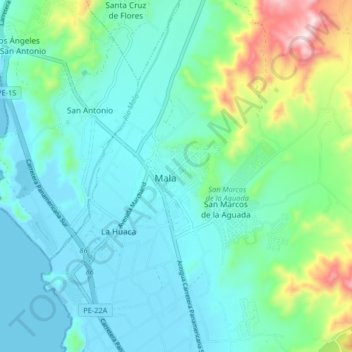
Name: Mala topographic map, elevation, terrain.

Location: Mala, Cañete, Lima, Perú (-12.69734 -76.66972 -12.61734 -76.58972)

Average elevation: 344 ft

Minimum elevation: -3 ft

Maximum elevation: 1,683 ft

Gear up for your next adventure:

🌎3D Topographic Globes - Raised relief globes for a tactile understanding of geography
🍳Camping Cook Set - Complete cookware for outdoor meals
🔪Outdoor Multitools - Essential survival tools for gear repair and field use
🗃️Trail First Aid Kit - Essential kit for outdoor injuries and emergencies
🧭GPS Watch Accessories - Bands and chargers for GPS watches

As an Amazon Associate, this site earns from qualifying purchases at no extra cost to you.