
Make a donation
Gear up for your next adventure:
As an Amazon Associate, this site earns from qualifying purchases at no extra cost to you.
Zoyatepec topographic map
Click on the map to display elevation.
Make a donation
Gear up for your next adventure:
As an Amazon Associate, this site earns from qualifying purchases at no extra cost to you.
About this map
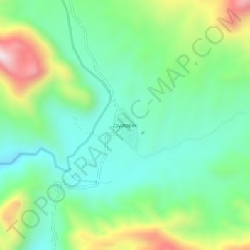
Name: Zoyatepec topographic map, elevation, terrain.
Location: Zoyatepec, Chilpancingo de los Bravo, Guerrero, México (17.31000 -99.57500 17.35000 -99.53500)
Average elevation: 2,835 ft
Minimum elevation: 2,116 ft
Maximum elevation: 4,429 ft
Make a donation
Gear up for your next adventure:
As an Amazon Associate, this site earns from qualifying purchases at no extra cost to you.
Other topographic maps
Click on a map to view its topography, its elevation and its terrain.
Deportivo "Los Galeana"
México > Guerrero > Chilpancingo de los Bravo > Chilpancingo de los Bravo
Average elevation: 4,393 ft
Parque de San Mateo
México > Guerrero > Chilpancingo de los Bravo > Chilpancingo de los Bravo
Average elevation: 4,321 ft