
Make a donation
Gear up for your next adventure:
As an Amazon Associate, this site earns from qualifying purchases at no extra cost to you.
Gager topographic map
Click on the map to display elevation.
Make a donation
Gear up for your next adventure:
As an Amazon Associate, this site earns from qualifying purchases at no extra cost to you.
Gager
Gager liegt auf der Halbinsel Mönchgut im Südostzipfel Rügens an der Südküste der Hagenschen Wiek und an der Nordküste des Zicker Sees. Dabei handelt es sich um zwei Buchten im Nordosten des Greifswalder Boddens. Die Ortschaft grenzt unmittelbar an den Höhenzug der Zickerschen Berge, deren höchste Erhebung der Bakenberg (66 m) ist. Der Berg befindet sich, wie die gesamten Zickerschen Berge, im Teilgebiet Zicker des Naturschutzgebietes Mönchgut.
Make a donation
Gear up for your next adventure:
As an Amazon Associate, this site earns from qualifying purchases at no extra cost to you.
About this map
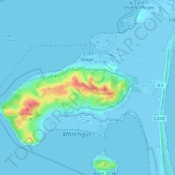
Name: Gager topographic map, elevation, terrain.
Average elevation: 16 ft
Minimum elevation: -16 ft
Maximum elevation: 203 ft
Make a donation
Gear up for your next adventure:
As an Amazon Associate, this site earns from qualifying purchases at no extra cost to you.
Other topographic maps
Click on a map to view its topography, its elevation and its terrain.
Groß Zicker
Deutschland > Mecklenburg-Vorpommern > Vorpommern-Rügen > Mönchgut > Groß Zicker
Average elevation: 16 ft