Geolocate

Hamilton Hill topographic map

Click on the map to display elevation.

About this map

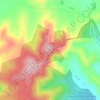
Name: Hamilton Hill topographic map, elevation, terrain.

Location: Hamilton Hill, Albury, Albury City Council, New South Wales, 2640, Australia (-36.01080 146.88289 -36.01070 146.88299)

Average elevation: 1,155 ft

Minimum elevation: 748 ft

Maximum elevation: 1,572 ft

Other topographic maps

Click on a map to view its topography, its elevation and its terrain.

Thurgoona

Australia > New South Wales > Albury

Average elevation: 633 ft

Lavington

Australia > New South Wales > Albury

Average elevation: 810 ft

Splitters Creek

Australia > New South Wales > Albury

The Splitters Creek valley is classed as a very high fire risk by the NSW Rural Fire Service (one of two in NSW) due to the topography and the access with only 1 road in and out.

Average elevation: 702 ft

North Albury

Australia > New South Wales > Albury

Average elevation: 587 ft

West Albury

Australia > New South Wales > Albury

Average elevation: 636 ft

Albury

Australia > New South Wales > Albury

Average elevation: 600 ft

Gear up for your next adventure:

🚪Portable Camp Chair - Foldable chair for comfort at camp
🪓Survival Multi‑Tool - Versatile tool for camp and trail tasks
🚗GPS Dash Cams - Record your scenic drives through mountain passes and canyons
🔥Fast-Boil Camping Stoves - Efficient cooking systems for quick trail meals
🪶Survival Guide Book - Expert advice for emergency preparedness

As an Amazon Associate, this site earns from qualifying purchases at no extra cost to you.