
Thank you for supporting this site ❤️
Make a donation
Make a donation
Gear up for your next adventure:
As an Amazon Associate, this site earns from qualifying purchases at no extra cost to you.
Thrissilery topographic map
Click on the map to display elevation.
Thank you for supporting this site ❤️
Make a donation
Make a donation
Gear up for your next adventure:
As an Amazon Associate, this site earns from qualifying purchases at no extra cost to you.
About this map
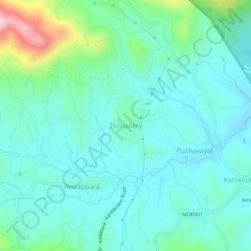
Name: Thrissilery topographic map, elevation, terrain.
Location: Thrissilery, Mananthavady, Wayanad, Kerala, 670646, India (11.83614 76.02400 11.87614 76.06400)
Average elevation: 2,657 ft
Minimum elevation: 2,375 ft
Maximum elevation: 3,816 ft
Thank you for supporting this site ❤️
Make a donation
Make a donation
Gear up for your next adventure:
As an Amazon Associate, this site earns from qualifying purchases at no extra cost to you.