
Make a donation
Gear up for your next adventure:
As an Amazon Associate, this site earns from qualifying purchases at no extra cost to you.
Le Canon topographic map
Click on the map to display elevation.
Make a donation
Gear up for your next adventure:
As an Amazon Associate, this site earns from qualifying purchases at no extra cost to you.
About this map
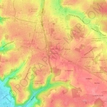
Name: Le Canon topographic map, elevation, terrain.
Average elevation: 203 ft
Minimum elevation: 7 ft
Maximum elevation: 282 ft
Make a donation
Gear up for your next adventure:
As an Amazon Associate, this site earns from qualifying purchases at no extra cost to you.
Other topographic maps
Click on a map to view its topography, its elevation and its terrain.
Cenon
France > Nouvelle-Aquitaine > Gironde > Floirac
Ce canton situé dans la région naturelle de l'Entre-deux-Mers sur la rive droite de la Garonne est organisé autour de Cenon. Ses trois communes appartiennent à la métropole de Bordeaux. Son altitude varie de 3 m (Cenon et Floirac) à 84 m (Bouliac).
Average elevation: 108 ft