Geolocate

Healdton topographic map

Click on the map to display elevation.

About this map

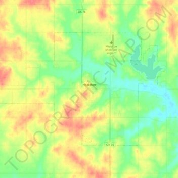
Name: Healdton topographic map, elevation, terrain.

Location: Healdton, Carter County, Oklahoma, 73438, United States (34.20187 -97.55141 34.26005 -97.44033)

Average elevation: 948 ft

Minimum elevation: 856 ft

Maximum elevation: 1,043 ft

Carter County trails, hiking, mountain biking, running and outdoor activities

Other topographic maps

Click on a map to view its topography, its elevation and its terrain.

Glenn

United States > Oklahoma > Carter County

Average elevation: 876 ft

Gear up for your next adventure:

🪶Trail Camera - Capture wildlife on your hikes
📚Navigation Handbooks - Master the art of reading topographic maps and using a compass
🌡️Portable Weather Meter - Track weather conditions on the trail
🌡️Handheld Weather Meters - Measure wind, temp, and pressure for safe mountain travel
🪓Survival Multi‑Tool - Versatile tool for camp and trail tasks

As an Amazon Associate, this site earns from qualifying purchases at no extra cost to you.