
Make a donation
Gear up for your next adventure:
As an Amazon Associate, this site earns from qualifying purchases at no extra cost to you.
Budoni topographic map
Click on the map to display elevation.
Make a donation
Gear up for your next adventure:
As an Amazon Associate, this site earns from qualifying purchases at no extra cost to you.
About this map
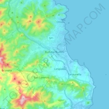
Name: Budoni topographic map, elevation, terrain.
Location: Budoni, Gallura Nord-Est Sardegna, Sardegna, 07051, Italia (40.65802 9.62413 40.75194 9.76711)
Average elevation: 259 ft
Minimum elevation: -10 ft
Maximum elevation: 1,654 ft
Make a donation
Gear up for your next adventure:
As an Amazon Associate, this site earns from qualifying purchases at no extra cost to you.
Other topographic maps
Click on a map to view its topography, its elevation and its terrain.
Faro di Punta Filetto
Italia > Sardegna > Gallura Nord-Est Sardegna > La Maddalena
Average elevation: 10 ft
Make a donation
Gear up for your next adventure:
As an Amazon Associate, this site earns from qualifying purchases at no extra cost to you.
Capo Coda Cavallo
Italia > Sardegna > Gallura Nord-Est Sardegna > San Teodoro
Average elevation: 16 ft
Make a donation
Gear up for your next adventure:
As an Amazon Associate, this site earns from qualifying purchases at no extra cost to you.
Malchisana
Italia > Sardegna > Gallura Nord-Est Sardegna > Santa Teresa Gallura
Average elevation: 253 ft
Make a donation
Gear up for your next adventure:
As an Amazon Associate, this site earns from qualifying purchases at no extra cost to you.