Geolocate

Jung-gu topographic map

Click on the map to display elevation.

About this map

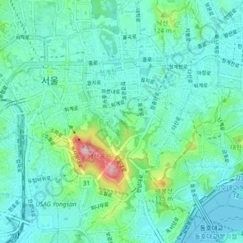
Name: Jung-gu topographic map, elevation, terrain.

Location: Jung-gu, Seoul, South Korea (37.54386 126.96154 37.57194 127.02678)

Average elevation: 171 ft

Minimum elevation: 16 ft

Maximum elevation: 869 ft

Other topographic maps

Click on a map to view its topography, its elevation and its terrain.

Cheonggyecheon (Stream)

South Korea > Seoul

Average elevation: 105 ft

Cheonggyecheon (Stream)

South Korea > Seoul

Average elevation: 98 ft

Cheonggyecheon (Stream)

South Korea > Seoul

Average elevation: 98 ft

달터마을

South Korea > Seoul

Average elevation: 177 ft

Ansan Mountain

South Korea > Seoul

Average elevation: 325 ft

Haebangchon

South Korea > Seoul

Average elevation: 243 ft

Jamsil Hanriver park

South Korea > Seoul

Average elevation: 56 ft

Gear up for your next adventure:

🪶Wildlife Field Guides - Learn animal tracking and species ID
🔪Outdoor Multitools - Essential survival tools for gear repair and field use
🧢Sun Protection Hats - Wide-brimmed and UPF-rated hats for high-altitude sun safety
🎒Gear Packing Cubes - Organize your backpack efficiently
🏕️Family Camping Gear - Essentials for group camping trips

As an Amazon Associate, this site earns from qualifying purchases at no extra cost to you.