
Make a donation
Gear up for your next adventure:
As an Amazon Associate, this site earns from qualifying purchases at no extra cost to you.
Palangka Raya topographic map
Click on the map to display elevation.
Make a donation
Gear up for your next adventure:
As an Amazon Associate, this site earns from qualifying purchases at no extra cost to you.
Palangka Raya
Palangka Raya borders Gunung Mas Regency to the north, Katingan Regency to the west, and Pulang Pisau Regency to the south and east. The area's soil consists mostly of peat and alluvium in its southern part and podzol on the northern part of the city. Overall, podzol soil dominates the city soil with 218,486 out of 285,349 hectares of city's landscape. Most of the city's topography is flat, with a general slope of less than 40 percent. Palangka Raya is mostly located around 35 meters above sea level.
Make a donation
Gear up for your next adventure:
As an Amazon Associate, this site earns from qualifying purchases at no extra cost to you.
About this map
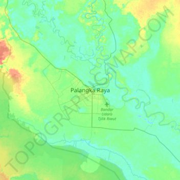
Name: Palangka Raya topographic map, elevation, terrain.
Location: Palangka Raya, Central Kalimantan, 73112, Indonesia (-2.36729 113.75644 -2.04729 114.07644)
Average elevation: 33 ft
Minimum elevation: -10 ft
Maximum elevation: 115 ft
Make a donation
Gear up for your next adventure:
As an Amazon Associate, this site earns from qualifying purchases at no extra cost to you.