Geolocate

Garadassi topographic map

Click on the map to display elevation.

About this map

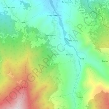
Name: Garadassi topographic map, elevation, terrain.

Location: Garadassi, Fabbrica Curone, Alessandria, Piemonte, 15054, Italia (44.73419 9.13399 44.77419 9.17399)

Average elevation: 2,608 ft

Minimum elevation: 1,640 ft

Maximum elevation: 4,373 ft

Gear up for your next adventure:

📱Solar Portable Charger - Solar power bank for charging devices off‑grid
🏫Relief Map Kits - Hands-on tools for teaching landforms and elevation
🧼Biodegradable Camping Soap - Eco‑friendly soap for outdoor hygiene
👖Convertible Hiking Pants - Versatile zip-off pants for changing altitudes and temperatures
🪶LED Camping Lantern - Bright lantern for camp lighting

As an Amazon Associate, this site earns from qualifying purchases at no extra cost to you.