
Parsippany topographic map
Click on the map to display elevation.
About this map
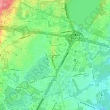
Name: Parsippany topographic map, elevation, terrain.
Average elevation: 312 ft
Minimum elevation: 207 ft
Maximum elevation: 525 ft
Morris County trails, hiking, mountain biking, running and outdoor activities
Other topographic maps
Click on a map to view its topography, its elevation and its terrain.
Parsippany
United States > New Jersey > Morris County > Parsippany-Troy Hills > Lake Hiawatha
Average elevation: 282 ft
Boonton Reservoir
United States > New Jersey > Morris County > Parsippany-Troy Hills > Lake Hiawatha
Average elevation: 335 ft
Rainbow Lakes
United States > New Jersey > Morris County > Parsippany-Troy Hills
Average elevation: 479 ft
Powder Mill Pond Dam
United States > New Jersey > Morris County > Parsippany-Troy Hills > Tabor
Average elevation: 584 ft
Boonton Reservoir
United States > New Jersey > Morris County > Parsippany-Troy Hills
Average elevation: 335 ft
Parsippany
United States > New Jersey > Morris County > Parsippany-Troy Hills > Lake Hiawatha
Average elevation: 282 ft
Parsippany
United States > New Jersey > Morris County > Parsippany-Troy Hills > Lake Hiawatha
Average elevation: 282 ft
Lake Hiawatha
United States > New Jersey > Morris County > Parsippany-Troy Hills > Lake Hiawatha
Average elevation: 259 ft