
Belmont topographic map
Interactive map
Click on the map to display elevation.
About this map
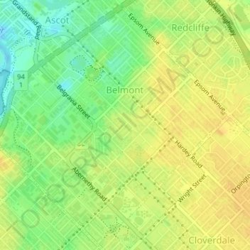
Name: Belmont topographic map, elevation, terrain.
Average elevation: 52 ft
Minimum elevation: -16 ft
Maximum elevation: 79 ft
Other topographic maps
Click on a map to view its topography, its elevation and its terrain.
Cloverdale
Australia > Western Australia > City of Belmont
Cloverdale, City of Belmont, Western Australia, 6105, Australia
Average elevation: 66 ft
Rivervale
Australia > Western Australia > City of Belmont
Rivervale, City of Belmont, Western Australia, 6103, Australia
Average elevation: 52 ft
Kewdale
Australia > Western Australia > City of Belmont
Kewdale, City of Belmont, Western Australia, 6105, Australia
Average elevation: 59 ft
Ascot
Australia > Western Australia > City of Belmont
Ascot, City of Belmont, Western Australia, 6104, Australia
Average elevation: 39 ft
Garvey Park
Australia > Western Australia > City of Belmont
Garvey Park, Ascot, City of Belmont, Western Australia, 6104, Australia
Average elevation: 36 ft
Adachi Park
Australia > Western Australia > City of Belmont
Adachi Park, Ascot, City of Belmont, Western Australia, 6104, Australia
Average elevation: 36 ft