Geolocate

Ascot topographic map

Interactive map

Click on the map to display elevation.

About this map

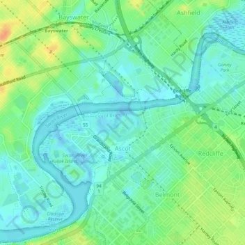
Name: Ascot topographic map, elevation, terrain.

Location: Ascot, City of Belmont, Western Australia, 6104, Australia (-31.94844 115.90878 -31.92041 115.95601)

Average elevation: 39 ft

Minimum elevation: -26 ft

Maximum elevation: 118 ft

Other topographic maps

Click on a map to view its topography, its elevation and its terrain.

Cloverdale

Australia > Western Australia > City of Belmont

Cloverdale, City of Belmont, Western Australia, 6105, Australia

Average elevation: 66 ft

Rivervale

Australia > Western Australia > City of Belmont

Rivervale, City of Belmont, Western Australia, 6103, Australia

Average elevation: 52 ft

Kewdale

Australia > Western Australia > City of Belmont

Kewdale, City of Belmont, Western Australia, 6105, Australia

Average elevation: 59 ft

Belmont

Australia > Western Australia > City of Belmont

Belmont, City of Belmont, Western Australia, 6103, Australia

Average elevation: 52 ft

Garvey Park

Australia > Western Australia > City of Belmont

Garvey Park, Ascot, City of Belmont, Western Australia, 6104, Australia

Average elevation: 36 ft

Adachi Park

Australia > Western Australia > City of Belmont

Adachi Park, Ascot, City of Belmont, Western Australia, 6104, Australia

Average elevation: 36 ft