
Thank you for supporting this site ❤️
Make a donation
Make a donation
Gear up for your next adventure:
As an Amazon Associate, this site earns from qualifying purchases at no extra cost to you.
Zikilingi topographic map
Click on the map to display elevation.
Thank you for supporting this site ❤️
Make a donation
Make a donation
Gear up for your next adventure:
As an Amazon Associate, this site earns from qualifying purchases at no extra cost to you.
About this map
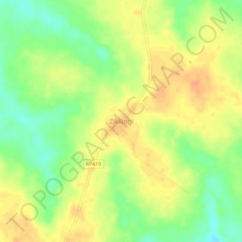
Name: Zikilingi topographic map, elevation, terrain.
Location: Zikilingi, Upper Uele, Democratic Republic of the Congo (4.29226 27.73967 4.33226 27.77967)
Average elevation: 2,365 ft
Minimum elevation: 2,293 ft
Maximum elevation: 2,418 ft
Thank you for supporting this site ❤️
Make a donation
Make a donation
Gear up for your next adventure:
As an Amazon Associate, this site earns from qualifying purchases at no extra cost to you.