
Make a donation
Gear up for your next adventure:
As an Amazon Associate, this site earns from qualifying purchases at no extra cost to you.
East Kilbride topographic map
Click on the map to display elevation.
Make a donation
Gear up for your next adventure:
As an Amazon Associate, this site earns from qualifying purchases at no extra cost to you.
East Kilbride
These findings have found further support through ongoing research indicating that many East Kilbride Cairns first noticed by the Reverend David Ure in his History of Rutherglen and East Kilbride (1793), are embedded, alongside other monuments, into a ritual landscape related to ancestor cults and relationships with key topographical features and annual solar events. A flint arrow head was discovered by Allan Forrest, a then child resident whilst groundworks were taking place in his family's garden at Glen Bervie, St Leonards in 1970 which later was identified as dating to 1500 BC (Bronze Age).
Make a donation
Gear up for your next adventure:
As an Amazon Associate, this site earns from qualifying purchases at no extra cost to you.
About this map
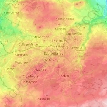
Name: East Kilbride topographic map, elevation, terrain.
Average elevation: 571 ft
Minimum elevation: 151 ft
Maximum elevation: 846 ft
Make a donation
Gear up for your next adventure:
As an Amazon Associate, this site earns from qualifying purchases at no extra cost to you.
Other topographic maps
Click on a map to view its topography, its elevation and its terrain.
Langlands Moss Lowland Raised Peatbog
United Kingdom > Scotland > South Lanarkshire > East Kilbride
Average elevation: 669 ft
Clyde Valley Family Park's Island
United Kingdom > Scotland > South Lanarkshire > Hazelbank > Birkhill
Average elevation: 390 ft
Craignethan Castle
United Kingdom > Scotland > South Lanarkshire > Crossford > Tillietudlem
Average elevation: 397 ft
Langlands Moss Local Nature Reserve
United Kingdom > Scotland > South Lanarkshire > East Kilbride
Average elevation: 669 ft
Make a donation
Gear up for your next adventure:
As an Amazon Associate, this site earns from qualifying purchases at no extra cost to you.
Trough Linn Woodlands Project
United Kingdom > Scotland > South Lanarkshire > East Kilbride
Average elevation: 607 ft
Make a donation
Gear up for your next adventure:
As an Amazon Associate, this site earns from qualifying purchases at no extra cost to you.
Low Banks
United Kingdom > Scotland > South Lanarkshire > Lamington > Millhill
Average elevation: 863 ft