
Make a donation
Gear up for your next adventure:
As an Amazon Associate, this site earns from qualifying purchases at no extra cost to you.
Sayram District topographic map
Click on the map to display elevation.
Make a donation
Gear up for your next adventure:
As an Amazon Associate, this site earns from qualifying purchases at no extra cost to you.
About this map
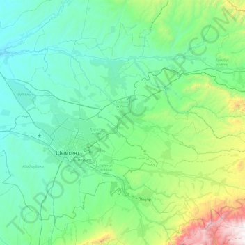
Name: Sayram District topographic map, elevation, terrain.
Location: Sayram District, Turkistan Region, Kazakhstan (42.16701 69.19378 42.63454 70.13771)
Average elevation: 2,467 ft
Minimum elevation: 984 ft
Maximum elevation: 10,420 ft
Make a donation
Gear up for your next adventure:
As an Amazon Associate, this site earns from qualifying purchases at no extra cost to you.
Other topographic maps
Click on a map to view its topography, its elevation and its terrain.
Қазақстан
Kazakhstan > Turkistan Region > Keles District > Бірлесу ауылдық округі
Average elevation: 1,030 ft
Дикан баба
Kazakhstan > Turkistan Region > Сарыагашский район > Дикан баба
Average elevation: 1,729 ft