Geolocate

Inari topographic map

Click on the map to display elevation.

About this map

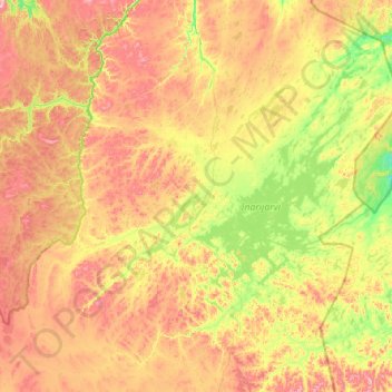
Name: Inari topographic map, elevation, terrain.

Location: Inari, Northern Lapland, Lapland, Mainland Finland, Finland (68.27757 24.90317 69.84919 29.33650)

Average elevation: 840 ft

Minimum elevation: 171 ft

Maximum elevation: 2,746 ft

Other topographic maps

Click on a map to view its topography, its elevation and its terrain.

Hammastunturi

Finland > Lapland > Inari

Average elevation: 1,299 ft

Levi Ski Resort

Finland > Lapland > Kittilä

Average elevation: 1,109 ft

Koutamaa

Finland > Lapland > Sirkka

Average elevation: 820 ft

Petsukka

Finland > Lapland > Sirkka

Average elevation: 673 ft

Ounasvaara

Finland > Lapland > Rovaniemi

Average elevation: 410 ft

Äkäslompolo

Finland > Lapland > Kolari

Average elevation: 846 ft

Kiilopää

Finland > Lapland > Sodankylä

Average elevation: 1,394 ft

Korvatunturi

Finland > Lapland > Savukoski

Average elevation: 1,017 ft

Luosto

Finland > Lapland > Sodankylä

Average elevation: 909 ft

Saana fell

Finland > Lapland > Enontekiö

Average elevation: 2,343 ft

Ylläsjärvi

Finland > Lapland > Kolari

Average elevation: 666 ft

Pyhätunturi

Finland > Lapland > Sodankylä

Average elevation: 1,129 ft

Otsamo

Finland > Lapland > Inari

Average elevation: 853 ft

Sokosti

Finland > Lapland > Sodankylä

Average elevation: 1,713 ft

Korouoma

Finland > Lapland > Posio

Average elevation: 764 ft

Karhunkierros

Finland > Lapland > Kolari

Average elevation: 407 ft

Kevo

Finland > Lapland > Utsjoki

Average elevation: 564 ft

Pokka

Finland > Lapland > Kittilä

Average elevation: 896 ft

Sirkka

Finland > Lapland

Average elevation: 755 ft

Kilpisjärvi

Finland > Lapland > Enontekiö

Although Kilpisjärvi is one of the largest villages in Enontekiö, it is still quite small. In 2000 its population was recorded as 114. Like most Sami villages, Kilpisjärvi is built mainly around one major road, Käsivarrentie, or the "Arm Road" and Neljäntuulentie, or the "Four Winds' Road" — also known…

Average elevation: 1,729 ft

Aapajoki

Finland > Lapland > Tornio

Average elevation: 79 ft

Vaattunki

Finland > Lapland > Rovaniemi

Average elevation: 394 ft

Laitavaara

Finland > Lapland > Pello

Average elevation: 515 ft

Yllästunturi

Finland > Lapland > Kolari

Average elevation: 1,683 ft

Saariselkä

Finland > Lapland

Average elevation: 1,076 ft

Gear up for your next adventure:

🛰️Handheld GPS Units - Professional satellite navigators for precise backcountry mapping
📌Outdoor GPS Map App - Apps and devices for digital topographic navigation
🎒Trekking Poles - Sturdy poles for balance and stability on rough terrain
🪄Magnetic Compass - Accurate compass for navigation
📷Action Cameras - Rugged cameras to document your journeys across rugged terrain

As an Amazon Associate, this site earns from qualifying purchases at no extra cost to you.