
Make a donation
Gear up for your next adventure:
As an Amazon Associate, this site earns from qualifying purchases at no extra cost to you.
Easter Island topographic map
Click on the map to display elevation.
Make a donation
Gear up for your next adventure:
As an Amazon Associate, this site earns from qualifying purchases at no extra cost to you.
About this map
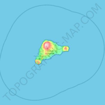
Name: Easter Island topographic map, elevation, terrain.
Location: Easter Island, Valparaiso Region, 2770000, Chile (-27.40200 -109.67958 -26.85500 -109.00299)
Average elevation: 16 ft
Minimum elevation: 0 ft
Maximum elevation: 1,644 ft
Make a donation
Gear up for your next adventure:
As an Amazon Associate, this site earns from qualifying purchases at no extra cost to you.
Other topographic maps
Click on a map to view its topography, its elevation and its terrain.
Ma'uŋa Te Hoŋa (O Koro)
Chile > Valparaiso Region > Easter Island Province > Easter Island
Average elevation: 837 ft
Chacarillas
Chile > Valparaiso Region > Provincia de San Antonio > Cartagena
Average elevation: 1,217 ft
Valle del Aconcagua
Chile > Valparaiso Region > Provincia de Quillota > Hijuelas > La Sombra
Average elevation: 1,145 ft
Make a donation
Gear up for your next adventure:
As an Amazon Associate, this site earns from qualifying purchases at no extra cost to you.
El Cobre
Chile > Valparaiso Region > Provincia de San Felipe de Aconcagua > Catemu
Average elevation: 1,795 ft
Hanga Roa
Chile > Valparaiso Region > Easter Island Province > Easter Island
Average elevation: 194 ft
Placilla de Peñuelas
Chile > Valparaiso Region > Provincia de Valparaíso > Valparaíso
Average elevation: 1,161 ft
Make a donation
Gear up for your next adventure:
As an Amazon Associate, this site earns from qualifying purchases at no extra cost to you.
Punta Pite
Chile > Valparaiso Region > Provincia de Petorca > Zapallar > Punta Pite Norte
Average elevation: 115 ft
La Chupalla
Chile > Valparaiso Region > Provincia de San Felipe de Aconcagua > Llay-Llay
Average elevation: 2,789 ft
Make a donation
Gear up for your next adventure:
As an Amazon Associate, this site earns from qualifying purchases at no extra cost to you.
Punta Roa
Chile > Valparaiso Region > Easter Island Province > Easter Island > Hanga Roa
Average elevation: 36 ft
Make a donation
Gear up for your next adventure:
As an Amazon Associate, this site earns from qualifying purchases at no extra cost to you.
Terevaka
Chile > Valparaiso Region > Easter Island Province > Easter Island
Terevaka is the 12th most topographically isolated summit on Earth.
Average elevation: 1,260 ft
Playa Laguna Verde
Chile > Valparaiso Region > Provincia de Valparaíso > Valparaíso > Laguna Verde
Average elevation: 230 ft
Los Rosales
Chile > Valparaiso Region > Provincia de Los Andes > Calle Larga
Average elevation: 4,052 ft
Make a donation
Gear up for your next adventure:
As an Amazon Associate, this site earns from qualifying purchases at no extra cost to you.
Hanga Roa
Chile > Valparaiso Region > Easter Island Province > Easter Island
Average elevation: 194 ft
Parque Tricao
Chile > Valparaiso Region > Provincia de San Antonio > Santo Domingo
Average elevation: 249 ft
Punta de Tralca
Chile > Valparaiso Region > Provincia de San Antonio > El Quisco
Average elevation: 144 ft
Make a donation
Gear up for your next adventure:
As an Amazon Associate, this site earns from qualifying purchases at no extra cost to you.
Las Terrazas
Chile > Valparaiso Region > Provincia de Petorca > Petorca > Hierro Viejo
Average elevation: 2,018 ft
Placilla de Peñuelas
Chile > Valparaiso Region > Provincia de Valparaíso > Valparaíso
Average elevation: 1,161 ft
Hanga Roa
Chile > Valparaiso Region > Easter Island Province > Easter Island
Average elevation: 194 ft
Viña del Mar
Chile > Valparaiso Region > Provincia de Valparaíso > Viña del Mar
Average elevation: 499 ft
Make a donation
Gear up for your next adventure:
As an Amazon Associate, this site earns from qualifying purchases at no extra cost to you.
Plaza Sucre
Chile > Valparaiso Region > Provincia de Valparaíso > Viña del Mar
Average elevation: 164 ft
Punta Pite
Chile > Valparaiso Region > Provincia de Petorca > Zapallar > Punta Pite Norte
Average elevation: 115 ft
Make a donation
Gear up for your next adventure:
As an Amazon Associate, this site earns from qualifying purchases at no extra cost to you.
Terevaka
Chile > Valparaiso Region > Easter Island Province
Terevaka is the 12th most topographically isolated summit on Earth.
Average elevation: 1,260 ft
Placilla de Peñuelas
Chile > Valparaiso Region > Provincia de Valparaíso > Valparaíso
Average elevation: 1,161 ft
Punta Pite
Chile > Valparaiso Region > Provincia de Petorca > Zapallar > Punta Pite Norte
Average elevation: 115 ft