
Thank you for supporting this site ❤️
Make a donation
Make a donation
Gear up for your next adventure:
As an Amazon Associate, this site earns from qualifying purchases at no extra cost to you.
Tongolo topographic map
Click on the map to display elevation.
Thank you for supporting this site ❤️
Make a donation
Make a donation
Gear up for your next adventure:
As an Amazon Associate, this site earns from qualifying purchases at no extra cost to you.
About this map
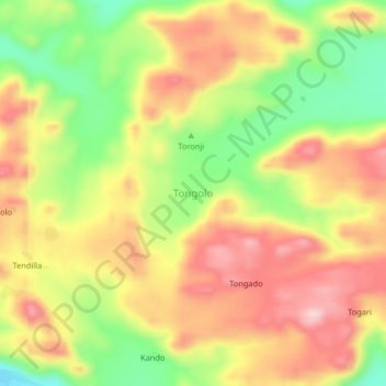
Name: Tongolo topographic map, elevation, terrain.
Location: Tongolo, Umm Dorain, Kadugli, South Kordufan, Sudan (10.69667 29.99667 10.73667 30.03667)
Average elevation: 2,011 ft
Minimum elevation: 1,591 ft
Maximum elevation: 2,365 ft
Thank you for supporting this site ❤️
Make a donation
Make a donation
Gear up for your next adventure:
As an Amazon Associate, this site earns from qualifying purchases at no extra cost to you.