
Thank you for supporting this site ❤️
Make a donation
Make a donation
Gear up for your next adventure:
As an Amazon Associate, this site earns from qualifying purchases at no extra cost to you.
Aripi topographic map
Click on the map to display elevation.
Thank you for supporting this site ❤️
Make a donation
Make a donation
Gear up for your next adventure:
As an Amazon Associate, this site earns from qualifying purchases at no extra cost to you.
About this map
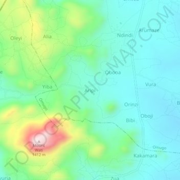
Name: Aripi topographic map, elevation, terrain.
Location: Aripi, Omugo, Arua, Northern Region, Uganda (3.21888 31.02139 3.25888 31.06139)
Average elevation: 3,501 ft
Minimum elevation: 3,104 ft
Maximum elevation: 4,636 ft
Thank you for supporting this site ❤️
Make a donation
Make a donation
Gear up for your next adventure:
As an Amazon Associate, this site earns from qualifying purchases at no extra cost to you.