
Steinhagen topographic map
Interactive map
Click on the map to display elevation.
About this map
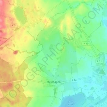
Name: Steinhagen topographic map, elevation, terrain.
Average elevation: 98 ft
Minimum elevation: 0 ft
Maximum elevation: 256 ft
Other topographic maps
Click on a map to view its topography, its elevation and its terrain.
Teterow
Duitsland > Mecklenburg-Voor-Pommeren > Landkreis Rostock
Teterow, Landkreis Rostock, Mecklenburg-Voor-Pommeren, 17166, Duitsland
Average elevation: 128 ft
Bad Doberan
Duitsland > Mecklenburg-Voor-Pommeren > Landkreis Rostock
Bad Doberan, Landkreis Rostock, Mecklenburg-Voor-Pommeren, 18209, Duitsland
Average elevation: 79 ft
Dudinghausen
Duitsland > Mecklenburg-Voor-Pommeren > Landkreis Rostock > Hohen Sprenz
Dudinghausen, Hohen Sprenz, Laage, Landkreis Rostock, Mecklenburg-Voor-Pommeren, Duitsland
Average elevation: 112 ft
Gorow
Duitsland > Mecklenburg-Voor-Pommeren > Landkreis Rostock > Satow
Gorow, Satow, Landkreis Rostock, Mecklenburg-Voor-Pommeren, 18239, Duitsland
Average elevation: 180 ft
Werle
Duitsland > Mecklenburg-Voor-Pommeren > Landkreis Rostock > Kassow > Werle
Werle, Kassow, Schwaan, Landkreis Rostock, Mecklenburg-Voor-Pommeren, 18258, Duitsland
Average elevation: 75 ft