
Thank you for supporting this site ❤️
Make a donation
Make a donation
Gear up for your next adventure:
As an Amazon Associate, this site earns from qualifying purchases at no extra cost to you.
Payahan topographic map
Click on the map to display elevation.
Thank you for supporting this site ❤️
Make a donation
Make a donation
Gear up for your next adventure:
As an Amazon Associate, this site earns from qualifying purchases at no extra cost to you.
About this map
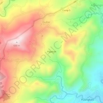
Name: Payahan topographic map, elevation, terrain.
Location: Payahan, Guba, Cebu City, Central Visayas, Philippines (10.39673 123.87210 10.43673 123.91210)
Average elevation: 1,073 ft
Minimum elevation: 157 ft
Maximum elevation: 2,047 ft
Thank you for supporting this site ❤️
Make a donation
Make a donation
Gear up for your next adventure:
As an Amazon Associate, this site earns from qualifying purchases at no extra cost to you.