Geolocate

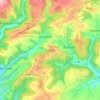
Oberkail topographic map

Click on the map to display elevation.

About this map

Name: Oberkail topographic map, elevation, terrain.

Location: Oberkail, Bitburger Land, Eifelkreis Bitburg-Prüm, Rijnland-Palts, Duitsland (50.01815 6.64163 50.09617 6.71895)

Average elevation: 1,457 ft

Minimum elevation: 997 ft

Maximum elevation: 1,844 ft

Other topographic maps

Click on a map to view its topography, its elevation and its terrain.

Buscht

Duitsland > Rijnland-Palts > Eifelkreis Bitburg-Prüm

Average elevation: 1,234 ft

Gear up for your next adventure:

🧴Hand Sanitizer - Keep hands clean while hiking
🧺Microfiber Travel Towels - Compact and fast-drying towels for trail use
🧢Outdoor Hiking Hat - Sun protection hat for outdoor explorers
📡Handheld GPS Device - Reliable handheld GPS for outdoor navigation
🔭Stargazing Telescopes - Perfect for camping in low-light pollution areas shown on maps

As an Amazon Associate, this site earns from qualifying purchases at no extra cost to you.