
Make a donation
Gear up for your next adventure:
As an Amazon Associate, this site earns from qualifying purchases at no extra cost to you.
Ratheim topographic map
Click on the map to display elevation.
Make a donation
Gear up for your next adventure:
As an Amazon Associate, this site earns from qualifying purchases at no extra cost to you.
Ratheim
Der Schwerpunkt der bebauten Flächen liegt auf der Mittelterrasse der Rur (circa 50 m ü.NN). Seit dem Rückgang der Hochwässer als Folge der Flussbegradigung wird auch der Bereich der Niederterrasse (40 m ü.NN) für die Wohnbebauung genutzt. Der steigende Bedarf an Wohnraum ab den 1960er Jahren führte außerdem zur Anlage und stetigen Erweiterung der Wohnsiedlung „Am Bammich“, die sich am Rande des Rurgrabens bis in eine Höhe von rund 82 m ü.NN erstreckt.
Make a donation
Gear up for your next adventure:
As an Amazon Associate, this site earns from qualifying purchases at no extra cost to you.
About this map
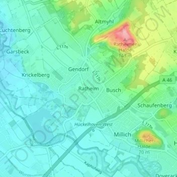
Name: Ratheim topographic map, elevation, terrain.
Average elevation: 197 ft
Minimum elevation: 118 ft
Maximum elevation: 492 ft
Make a donation
Gear up for your next adventure:
As an Amazon Associate, this site earns from qualifying purchases at no extra cost to you.
Other topographic maps
Click on a map to view its topography, its elevation and its terrain.
41836
Deutschland > Nordrhein-Westfalen > Kreis Heinsberg > Hückelhoven > Doveren > Doverheide
Average elevation: 184 ft