
Thank you for supporting this site ❤️
Make a donation
Make a donation
Gear up for your next adventure:
As an Amazon Associate, this site earns from qualifying purchases at no extra cost to you.
Obernaundorf topographic map
Click on the map to display elevation.
Thank you for supporting this site ❤️
Make a donation
Make a donation
Gear up for your next adventure:
As an Amazon Associate, this site earns from qualifying purchases at no extra cost to you.
Obernaundorf
Nahe dem Freigut entspringt der Vorholzbach sowie in der Geßliche das gleichnamige Bächlein. Im Nordosten erhebt sich der Wachtelberg (369,3 m über Meereshöhe), im Nordwesten der Kahler-Berg (335,2 m über Meereshöhe).
Thank you for supporting this site ❤️
Make a donation
Make a donation
Gear up for your next adventure:
As an Amazon Associate, this site earns from qualifying purchases at no extra cost to you.
About this map
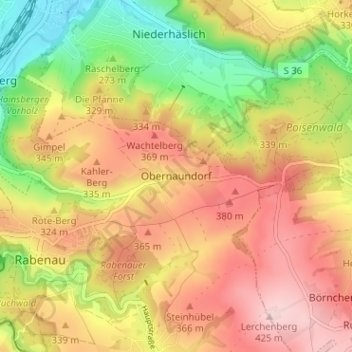
Name: Obernaundorf topographic map, elevation, terrain.
Average elevation: 1,017 ft
Minimum elevation: 574 ft
Maximum elevation: 1,394 ft
Thank you for supporting this site ❤️
Make a donation
Make a donation
Gear up for your next adventure:
As an Amazon Associate, this site earns from qualifying purchases at no extra cost to you.