
Hilzingen topographic map
Click on the map to display elevation.
About this map
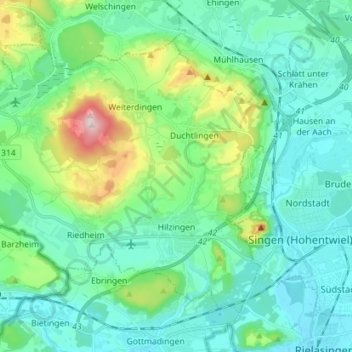
Name: Hilzingen topographic map, elevation, terrain.
Location: Hilzingen, Landkreis Konstanz, Baden-Württemberg, 78247, Germany (47.74177 8.68359 47.81550 8.82577)
Average elevation: 1,634 ft
Minimum elevation: 1,371 ft
Maximum elevation: 2,654 ft
Other topographic maps
Click on a map to view its topography, its elevation and its terrain.
Bleiche
Germany > Baden-Württemberg > Landkreis Konstanz > Stockach > Hindelwangen
Average elevation: 1,860 ft
Alte Ölmühle
Germany > Baden-Württemberg > Landkreis Konstanz > Engen > Anselfingen
Average elevation: 1,841 ft
Rickelshausen
Germany > Baden-Württemberg > Landkreis Konstanz > Radolfzell am Bodensee > Böhringen
Average elevation: 1,332 ft