
Thank you for supporting this site ❤️
Make a donation
Make a donation
Gear up for your next adventure:
As an Amazon Associate, this site earns from qualifying purchases at no extra cost to you.
Larrazet topographic map
Click on the map to display elevation.
Thank you for supporting this site ❤️
Make a donation
Make a donation
Gear up for your next adventure:
As an Amazon Associate, this site earns from qualifying purchases at no extra cost to you.
About this map
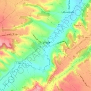
Name: Larrazet topographic map, elevation, terrain.
Average elevation: 459 ft
Minimum elevation: 272 ft
Maximum elevation: 689 ft
Thank you for supporting this site ❤️
Make a donation
Make a donation
Gear up for your next adventure:
As an Amazon Associate, this site earns from qualifying purchases at no extra cost to you.
Other topographic maps
Click on a map to view its topography, its elevation and its terrain.
Point Accueil Jeunes (PAJ) de Saint-Antonin
Frankrijk > Occitanië > Tarn-et-Garonne > Saint-Antonin-Noble-Val > Marsac
Average elevation: 764 ft