
Make a donation
Gear up for your next adventure:
As an Amazon Associate, this site earns from qualifying purchases at no extra cost to you.
Homeworth topographic map
Click on the map to display elevation.
Make a donation
Gear up for your next adventure:
As an Amazon Associate, this site earns from qualifying purchases at no extra cost to you.
About this map
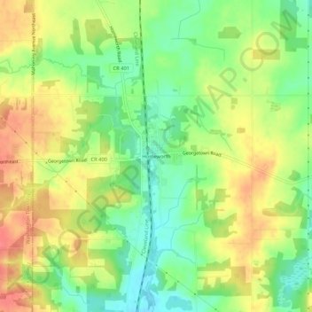
Name: Homeworth topographic map, elevation, terrain.
Location: Homeworth, Columbiana County, Ohio, 44634, United States (40.81534 -81.08593 40.85534 -81.04593)
Average elevation: 1,211 ft
Minimum elevation: 1,109 ft
Maximum elevation: 1,312 ft
Columbiana County trails, hiking, mountain biking, running and outdoor activities
Make a donation
Gear up for your next adventure:
As an Amazon Associate, this site earns from qualifying purchases at no extra cost to you.
Other topographic maps
Click on a map to view its topography, its elevation and its terrain.
Make a donation
Gear up for your next adventure:
As an Amazon Associate, this site earns from qualifying purchases at no extra cost to you.
Highlandtown Lake Dam
United States > Ohio > Columbiana County > Highlandtown
Average elevation: 1,129 ft
Beaver Creek State Park
United States > Ohio > Columbiana County > Calcutta
Average elevation: 1,047 ft
Make a donation
Gear up for your next adventure:
As an Amazon Associate, this site earns from qualifying purchases at no extra cost to you.
Summitville
United States > Ohio > Columbiana County
Summitville was laid out in 1853. The village was so named on account of its lofty elevation near one of the highest points between the Sandy Creek and Lake Erie.
Average elevation: 1,152 ft