Geolocate

Bodenfelde topographic map

Click on the map to display elevation.

About this map

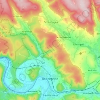
Name: Bodenfelde topographic map, elevation, terrain.

Location: Bodenfelde, Landkreis Northeim, Lower Saxony, 37194, Germany (51.62452 9.45058 51.70501 9.59735)

Average elevation: 778 ft

Minimum elevation: 315 ft

Maximum elevation: 1,512 ft

Other topographic maps

Click on a map to view its topography, its elevation and its terrain.

Clus

Germany > Lower Saxony > Landkreis Northeim > Bad Gandersheim

Average elevation: 554 ft

Asche

Germany > Lower Saxony > Landkreis Northeim > Hardegsen

Average elevation: 827 ft

Angerstein

Germany > Lower Saxony > Landkreis Northeim

Average elevation: 551 ft

Balos

Germany > Lower Saxony > Landkreis Northeim > Moringen

Average elevation: 961 ft

Gear up for your next adventure:

🧦Hiking Socks - Comfortable socks to prevent blisters on long hikes
🔋Solar Power Banks - Keep your GPS and phone charged in remote wilderness areas
🗺️NatGeo Topo Maps - High-quality waterproof printed topographic maps of US Parks
🗺️Topographic Maps - Detailed topo maps for hiking, exploring and outdoor navigation
🚑Emergency Bivvies - Heat-reflective sleeping bags for survival situations

As an Amazon Associate, this site earns from qualifying purchases at no extra cost to you.