Geolocate

Wheeler topographic map

Click on the map to display elevation.

About this map

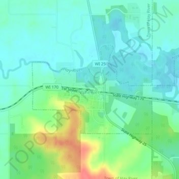
Name: Wheeler topographic map, elevation, terrain.

Location: Wheeler, Dunn County, Wisconsin, United States (45.03810 -91.92050 45.05150 -91.88552)

Average elevation: 945 ft

Minimum elevation: 889 ft

Maximum elevation: 1,086 ft

Dunn County trails, hiking, mountain biking, running and outdoor activities

Other topographic maps

Click on a map to view its topography, its elevation and its terrain.

Graytown

United States > Wisconsin > Dunn County

Average elevation: 1,129 ft

Caryville

United States > Wisconsin > Dunn County

Average elevation: 791 ft

Downsville

United States > Wisconsin > Dunn County

Average elevation: 837 ft

Rock Falls

United States > Wisconsin > Dunn County

Average elevation: 869 ft

Wilson Park

United States > Wisconsin > Dunn County > Menomonie

Average elevation: 876 ft

Canary Island

United States > Wisconsin > Dunn County > Menomonie

Average elevation: 1,014 ft

Gear up for your next adventure:

👟Men's Trail Runners - Lightweight footwear for fast-paced exploration and light hiking
🔥Plasma Lighters - Windproof lighters that work in any weather condition
🛶Inflatable Kayak - Portable kayak for rivers, lakes, and expeditions
🚁Photography Drones - Capture stunning aerial views of landforms and topography
🌄Hiking Binoculars - Compact binoculars for scenic views and trail spotting

As an Amazon Associate, this site earns from qualifying purchases at no extra cost to you.