
Make a donation
Gear up for your next adventure:
As an Amazon Associate, this site earns from qualifying purchases at no extra cost to you.
Kuşçu topographic map
Click on the map to display elevation.
Make a donation
Gear up for your next adventure:
As an Amazon Associate, this site earns from qualifying purchases at no extra cost to you.
About this map
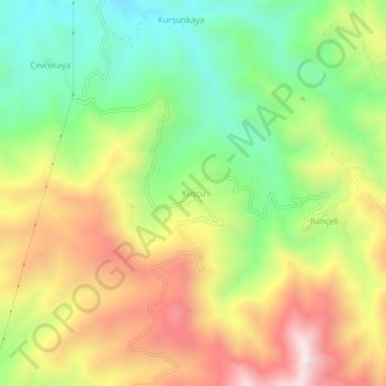
Name: Kuşçu topographic map, elevation, terrain.
Location: Kuşçu, Keban, Elazığ, Eastern Anatolia Region, Turkey (38.69982 38.72883 38.73982 38.76883)
Average elevation: 4,485 ft
Minimum elevation: 3,268 ft
Maximum elevation: 5,968 ft
Make a donation
Gear up for your next adventure:
As an Amazon Associate, this site earns from qualifying purchases at no extra cost to you.
Other topographic maps
Click on a map to view its topography, its elevation and its terrain.
Keban Dam
The Keban Dam is a combined rockfill and concrete gravity hydroelectric dam operated by the State Hydraulic Works (DSİ). The dam is 1,097 metres (3,599 ft) long and its crest is 207 metres (679 ft) above the level of the river-bed (848 metres (2,782 ft) above sea-level). Its eight water turbines are capable…
Average elevation: 2,769 ft