
Westmere topographic map
Click on the map to display elevation.
About this map
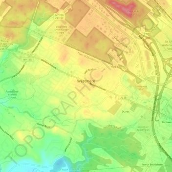
Name: Westmere topographic map, elevation, terrain.
Average elevation: 259 ft
Minimum elevation: 95 ft
Maximum elevation: 397 ft
Albany County trails, hiking, mountain biking, running and outdoor activities
Other topographic maps
Click on a map to view its topography, its elevation and its terrain.
Hartmans Corners
United States > New York > Albany County > Town of Guilderland
Average elevation: 266 ft
Guilderland Center
United States > New York > Albany County > Town of Guilderland
Average elevation: 315 ft