
Make a donation
Gear up for your next adventure:
As an Amazon Associate, this site earns from qualifying purchases at no extra cost to you.
Distrito La Chorrera topographic map
Click on the map to display elevation.
Make a donation
Gear up for your next adventure:
As an Amazon Associate, this site earns from qualifying purchases at no extra cost to you.
About this map
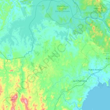
Name: Distrito La Chorrera topographic map, elevation, terrain.
Location: Distrito La Chorrera, Panamá Oeste, Panama (8.77427 -79.99104 9.18600 -79.70403)
Average elevation: 299 ft
Minimum elevation: 0 ft
Maximum elevation: 1,847 ft
Make a donation
Gear up for your next adventure:
As an Amazon Associate, this site earns from qualifying purchases at no extra cost to you.
Other topographic maps
Click on a map to view its topography, its elevation and its terrain.
Panama Pacifico
Panama > Panamá Oeste > Distrito Arraiján > Veracruz > Panama Pacifico
Average elevation: 79 ft
Make a donation
Gear up for your next adventure:
As an Amazon Associate, this site earns from qualifying purchases at no extra cost to you.