
Make a donation
Gear up for your next adventure:
As an Amazon Associate, this site earns from qualifying purchases at no extra cost to you.
Volcán Chichinautzin topographic map
Click on the map to display elevation.
Make a donation
Gear up for your next adventure:
As an Amazon Associate, this site earns from qualifying purchases at no extra cost to you.
About this map
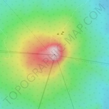
Name: Volcán Chichinautzin topographic map, elevation, terrain.
Location: Volcán Chichinautzin, Mexico City, 14904, Mexico (19.08937 -99.13565 19.08947 -99.13555)
Average elevation: 10,630 ft
Minimum elevation: 10,174 ft
Maximum elevation: 11,345 ft
Make a donation
Gear up for your next adventure:
As an Amazon Associate, this site earns from qualifying purchases at no extra cost to you.
Other topographic maps
Click on a map to view its topography, its elevation and its terrain.
Iztacalco
The borough extends over 23.1 km2 or 2,317.4 hectares, all of which is urbanized. It accounts for 1.75% of the total territory of Mexico City, and it is the smallest of the 16 boroughs. The land is flat and located on the lakebed of Lake Texcoco in the Valley of Mexico at an altitude of 2,235 meters above sea…
Average elevation: 7,323 ft