
Make a donation
Gear up for your next adventure:
As an Amazon Associate, this site earns from qualifying purchases at no extra cost to you.
Techirghiol topographic map
Click on the map to display elevation.
Make a donation
Gear up for your next adventure:
As an Amazon Associate, this site earns from qualifying purchases at no extra cost to you.
Techirghiol
Town is in the south east extremity of Romania (Constanța County), situated on the north west shore of Lake Techirghiol (11.6 km2), elevation 15–20 m, 18 km south of the municipality of Constanța and very close to the Black Sea (3 km).
Make a donation
Gear up for your next adventure:
As an Amazon Associate, this site earns from qualifying purchases at no extra cost to you.
About this map
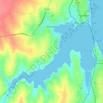
Name: Techirghiol topographic map, elevation, terrain.
Average elevation: 75 ft
Minimum elevation: -13 ft
Maximum elevation: 243 ft
Make a donation
Gear up for your next adventure:
As an Amazon Associate, this site earns from qualifying purchases at no extra cost to you.
Other topographic maps
Click on a map to view its topography, its elevation and its terrain.