
Valencia topographic map
Click on the map to display elevation.
About this map
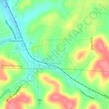
Name: Valencia topographic map, elevation, terrain.
Location: Valencia, Butler County, Pennsylvania, United States (40.67328 -79.99555 40.68073 -79.98141)
Average elevation: 1,152 ft
Minimum elevation: 1,027 ft
Maximum elevation: 1,319 ft
Butler County trails, hiking, mountain biking, running and outdoor activities
Other topographic maps
Click on a map to view its topography, its elevation and its terrain.
Buhls Station
United States > Pennsylvania > Butler County > Buhls Station
Average elevation: 1,102 ft
Glen Eden
United States > Pennsylvania > Butler County > Cranberry Township
Average elevation: 1,148 ft
Petersville
United States > Pennsylvania > Butler County > Connoquenessing > Petersville
Average elevation: 1,207 ft