Geolocate

Delhi topographic map

Click on the map to display elevation.

About this map

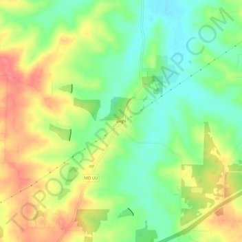
Name: Delhi topographic map, elevation, terrain.

Location: Delhi, Crawford County, Missouri, United States (38.10838 -91.36765 38.14838 -91.32765)

Average elevation: 925 ft

Minimum elevation: 817 ft

Maximum elevation: 1,050 ft

Crawford County trails, hiking, mountain biking, running and outdoor activities

Other topographic maps

Click on a map to view its topography, its elevation and its terrain.

West Sullivan

United States > Missouri > Crawford County

Average elevation: 971 ft

Cuba

United States > Missouri > Crawford County

Average elevation: 994 ft

Steelville

United States > Missouri > Crawford County

Average elevation: 840 ft

Gear up for your next adventure:

🔌Solar Panel Charger - Charge gear sustainably outdoors
🪓Survival Multi‑Tool - Versatile tool for camp and trail tasks
Backpacking Tents - Weight-optimized shelters for multi-day topographic surveys
Solar GPS Watches - Advanced multisport watches with built-in topographic maps
🔋Solar Power Banks - Keep your GPS and phone charged in remote wilderness areas

As an Amazon Associate, this site earns from qualifying purchases at no extra cost to you.