
Center City topographic map
Click on the map to display elevation.
About this map
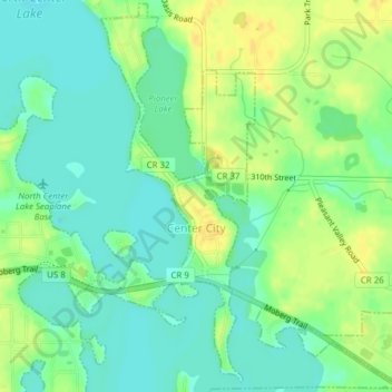
Name: Center City topographic map, elevation, terrain.
Location: Center City, Chisago County, Minnesota, United States (45.38279 -92.82925 45.40930 -92.79508)
Average elevation: 915 ft
Minimum elevation: 876 ft
Maximum elevation: 961 ft
Chisago County trails, hiking, mountain biking, running and outdoor activities
Other topographic maps
Click on a map to view its topography, its elevation and its terrain.
Chain Lake
United States > Minnesota > Chisago County > North Branch > Harris
Average elevation: 922 ft