Geolocate

New Albin topographic map

Click on the map to display elevation.

About this map

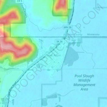
Name: New Albin topographic map, elevation, terrain.

Location: New Albin, Allamakee County, Iowa, United States (43.49265 -91.29368 43.50085 -91.28239)

Average elevation: 686 ft

Minimum elevation: 614 ft

Maximum elevation: 1,093 ft

Allamakee County trails, hiking, mountain biking, running and outdoor activities

Other topographic maps

Click on a map to view its topography, its elevation and its terrain.

Elon

United States > Iowa > Allamakee County

Average elevation: 1,099 ft

Dorchester

United States > Iowa > Allamakee County

Average elevation: 984 ft

Gear up for your next adventure:

📖Nature Tracking Books - Learn to track wildlife and terrain
🪶Survival Guide Book - Expert advice for emergency preparedness
👟Trail Running Shoes - Lightweight shoes for trail runners
🚪Portable Camp Chair - Foldable chair for comfort at camp
🔥Plasma Lighters - Windproof lighters that work in any weather condition

As an Amazon Associate, this site earns from qualifying purchases at no extra cost to you.