
Make a donation
Gear up for your next adventure:
As an Amazon Associate, this site earns from qualifying purchases at no extra cost to you.
Craytonville topographic map
Click on the map to display elevation.
Make a donation
Gear up for your next adventure:
As an Amazon Associate, this site earns from qualifying purchases at no extra cost to you.
About this map
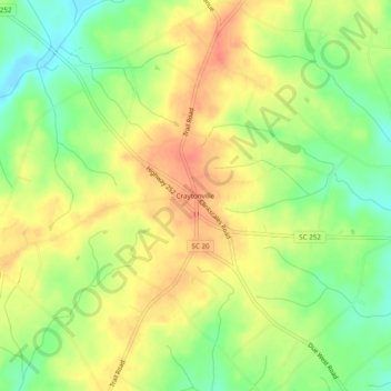
Name: Craytonville topographic map, elevation, terrain.
Location: Craytonville, Anderson County, South Carolina, United States (34.41622 -82.50290 34.45622 -82.46290)
Average elevation: 751 ft
Minimum elevation: 659 ft
Maximum elevation: 827 ft
Anderson County trails, hiking, mountain biking, running and outdoor activities
Make a donation
Gear up for your next adventure:
As an Amazon Associate, this site earns from qualifying purchases at no extra cost to you.
Other topographic maps
Click on a map to view its topography, its elevation and its terrain.
Homeland Park
United States > South Carolina > Anderson County > Varennes Heights
Average elevation: 768 ft
Centerville
United States > South Carolina > Anderson County > Gilmer Estates
Average elevation: 791 ft
Make a donation
Gear up for your next adventure:
As an Amazon Associate, this site earns from qualifying purchases at no extra cost to you.
Make a donation
Gear up for your next adventure:
As an Amazon Associate, this site earns from qualifying purchases at no extra cost to you.