
Yorktown topographic map
Click on the map to display elevation.
About this map
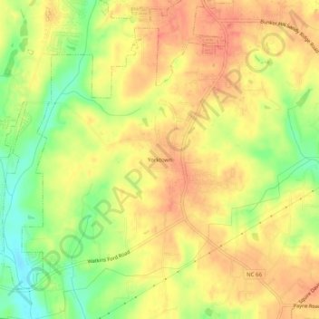
Name: Yorktown topographic map, elevation, terrain.
Average elevation: 915 ft
Minimum elevation: 807 ft
Maximum elevation: 981 ft
Forsyth County trails, hiking, mountain biking, running and outdoor activities
Other topographic maps
Click on a map to view its topography, its elevation and its terrain.
Salem Lake
United States > North Carolina > Forsyth County > Winston-Salem > Woodbridge
Average elevation: 866 ft
Salem Creek
United States > North Carolina > Forsyth County > Winston-Salem > Salem
Average elevation: 823 ft