Geolocate

Wake topographic map

Click on the map to display elevation.

About this map

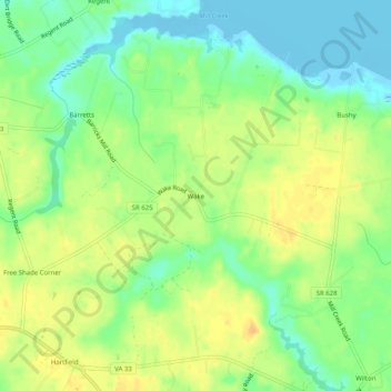
Name: Wake topographic map, elevation, terrain.

Location: Wake, Middlesex County, Virginia, 23176, United States (37.54819 -76.44911 37.58819 -76.40911)

Average elevation: 52 ft

Minimum elevation: -13 ft

Maximum elevation: 102 ft

Middlesex County trails, hiking, mountain biking, running and outdoor activities

Other topographic maps

Click on a map to view its topography, its elevation and its terrain.

Urbanna

United States > Virginia > Middlesex County

Average elevation: 26 ft

Gear up for your next adventure:

🎒Hydration Pack - Hands‑free water reservoir for long hikes
📶Vehicle Signal Boosters - Improve reception in rural areas while driving to trailheads
🥤Water Filter Bottle - All‑in‑one filter bottle for safe hydration
🪶Wildlife Field Guides - Learn animal tracking and species ID
🪶Trail Camera - Capture wildlife on your hikes

As an Amazon Associate, this site earns from qualifying purchases at no extra cost to you.