Geolocate

Chomes topographic map

Click on the map to display elevation.

About this map

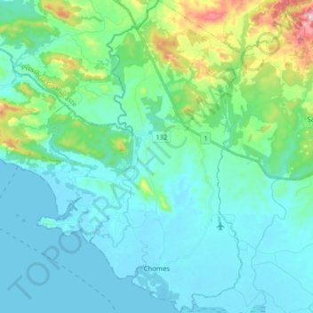
Name: Chomes topographic map, elevation, terrain.

Location: Chomes, Cantón de Puntarenas, Puntarenas, 60103, Costa Rica (10.02112 -84.98537 10.17639 -84.86495)

Average elevation: 269 ft

Minimum elevation: -7 ft

Maximum elevation: 1,565 ft

Other topographic maps

Click on a map to view its topography, its elevation and its terrain.

Carmen

Costa Rica > Cantón de Puntarenas > Cóbano

Average elevation: 243 ft

Gear up for your next adventure:

📖Nature Tracking Books - Learn to track wildlife and terrain
🌡️Handheld Weather Meters - Measure wind, temp, and pressure for safe mountain travel
🚁Photography Drones - Capture stunning aerial views of landforms and topography
🧺Microfiber Travel Towels - Compact and fast-drying towels for trail use
🧷Carabiner Set - Durable clips for gear attachment

As an Amazon Associate, this site earns from qualifying purchases at no extra cost to you.